News
Welcome to the News community!
Rules:
1. Be civil
Attack the argument, not the person. No racism/sexism/bigotry. Good faith argumentation only. This includes accusing another user of being a bot or paid actor. Trolling is uncivil and is grounds for removal and/or a community ban. Do not respond to rule-breaking content; report it and move on.
2. All posts should contain a source (url) that is as reliable and unbiased as possible and must only contain one link.
Obvious right or left wing sources will be removed at the mods discretion. Supporting links can be added in comments or posted seperately but not to the post body.
3. No bots, spam or self-promotion.
Only approved bots, which follow the guidelines for bots set by the instance, are allowed.
4. Post titles should be the same as the article used as source.
Posts which titles don’t match the source won’t be removed, but the autoMod will notify you, and if your title misrepresents the original article, the post will be deleted. If the site changed their headline, the bot might still contact you, just ignore it, we won’t delete your post.
5. Only recent news is allowed.
Posts must be news from the most recent 30 days.
6. All posts must be news articles.
No opinion pieces, Listicles, editorials or celebrity gossip is allowed. All posts will be judged on a case-by-case basis.
7. No duplicate posts.
If a source you used was already posted by someone else, the autoMod will leave a message. Please remove your post if the autoMod is correct. If the post that matches your post is very old, we refer you to rule 5.
8. Misinformation is prohibited.
Misinformation / propaganda is strictly prohibited. Any comment or post containing or linking to misinformation will be removed. If you feel that your post has been removed in error, credible sources must be provided.
9. No link shorteners.
The auto mod will contact you if a link shortener is detected, please delete your post if they are right.
10. Don't copy entire article in your post body
For copyright reasons, you are not allowed to copy an entire article into your post body. This is an instance wide rule, that is strictly enforced in this community.
Does that map suggest that a few cities are rising? Memphis, San Jose, Jacksonville...
The article says that the uplift on these cities is so minimal it might as well be 0.
Yeah, that makes sense
What's pushing them up?
Most likely, statistical variance.
This may be the best low key banger of a comment I've seen all year. Congrats on winn in ng the internet today
Edit: leaving the shitty phone typing
🦅: "DEI soil"
I'm kind of disappointed new orleans isn't on this list
I'm disappointed most of Florida isn't sinking back into Hell.
the ocean is reclaiming florida, plus invasive species are also taking over, floridas obsession with reptiles.
It is, but they can’t put the cities on the list relative to non-cities in FL since the entire state is sinking.
other than the ocean, invasive species are overtaking florida too. reticulated pythons, green anacondas, giant snails, giant rats.
Its population is too small to make it into this study, but it was mentioned in the press release from Colombia alongside Venice and Jakarta as rapidly subsiding coastal metropolises that have drawn media attention.
Isn't Colombia where Jeff got his law degree?
Ya but do any of these other places have songs about them sinking?
Well ... cities are heavy.
It's mostly because they're pumping all the water and oil out of the ground which makes empty spaces for everything to sink into
Lol at first I thought they were talking about population shrinking.
Not my problem. I also like how the chart has a legend showing what colors they would use if the city was rising. "Albuquerque is getting taller!"
The nation's fastest-sinking city is Houston, with more than 40% of its area dropping more than 5 millimeters (about 1/5 inch) per year, and 12% sinking at twice that rate.
kagis
https://texaslivingwaters.org/groundwater/subsidence-houston-galveston-region/
Understanding subsidence in the Houston-Galveston region
Since 1836, groundwater withdrawals have caused about 3,200 square miles of the Houston-Galveston area to subside (or sink) more than a foot, with some areas subsiding as much as 12 to 13 feet.
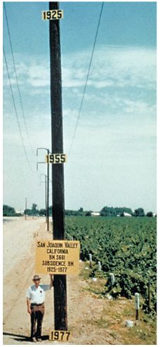
Noob-tier numbers, Texas. Here's a photo from 1977 in California showing land subsidence on a telephone pole from 1925 to 1977.
https://water.usgs.gov/ogw/pubs/fs00165/Images/fig2.jpg

My brain isn't working? The pole was installed and ground receded 9 meters over the years? How far into the ground was the pole driven in the beginning?
No, here's the caption.
Figure 2. Approximate location of maximum subsidence in the United States identified by research efforts of Dr. Joseph F. Poland (pictured). Signs on pole show approximate altitude of land surface in 1925, 1955, and 1977. The site is in the San Joaquin Valley southwest of Mendota, California.
Link is here
https://water.usgs.gov/ogw/pubs/fs00165/
It uses the word 'aquitards' which is what my partner will undoubtedly be calling me when I go swimming
I'll never remember that word when I need it the most :(
The pole is just an ordinary pole. In 1977, after measuring land subsidence over time, they put the signs up on it to illustrate how far the land had sunk. They could have put the signs on anything tall enough to provide enough space.
Yeah that makes way more sense... thanks
What are they sinking about?
sanks for se choke
How do you think the unthinkable? With an ithberg! -Mike Tyson (probably)
Thienthe thtuff.