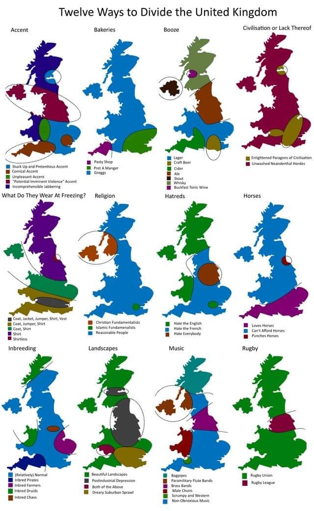
I didn't really enjoy this.
Casual UK
Casual UK
A casual place for banter and anything that doesn't fit in anywhere else.
Have chat and a natter. Talk about anything and everything that's not political!
Keep it casual.
Rules
- No politics.
- Be friendly.
- Be kind & civil.
- Follow Feddit.uk site rules.
Other communities:
Here:
Elsewhere:
Sorry. Hanging head in shame, etc. I found it mildly entertaining how grossly wrong it was on every single level.
Post-industrial depression landscape in the Cumbrian mountains? Or Yorkshire? The Pennines?
I know. 12 maps, 0 correct.
I was very confused by the shape of this United Kingdom. For reference, this is what it actually looks like:

I'm guessing, they left out all the islands, but even then, it still doesn't look terribly accurate to me, so no idea...
Wow, that dam between northern Ireland and the Republic of Ireland has really come along in this better map. United Kingdom is great Britain and northern Ireland, for reference.
They rotated it slightly to get the south coast more horizontal and binned off most islands (the Shetlands and Orkneys I can understand but the Isle of Man wasn't in the way).so they could pack more into the space.
Check your mailbox
Careful what you call United Kingdom! They left out Ireland because it's not part of UK
Ah yeah, good point. I was very confused by Southern Ireland missing on their map, too, but my comment made it sound like that's part of the UK.
You also want to be careful using terms like 'Southern Ireland'. Northern Ireland is a thing, and the Republic of Ireland is a thing...
Yes, I decided to call it "Southern Ireland", because I doubt many people outside of Europe will know which one of the two Irelands is the "Republic of Ireland".
I did look up beforehand, if I'm allowed to say "Southern Ireland" without being crucified and Wikipedia said ~~yes~~ maybe: https://en.wikipedia.org/wiki/Southern_Ireland
Mostly attacking Scotland and anywhere that hasn't London. Shite.
Accents are a million so not a good way to divide.
Also whoever did this. Do you think s it's eat haggis all day drinking whiskey and playing the bagpipes.
A child perhaps or London knob. Racist
I think it might not have been entirely serious, mate.
I assumed the whole thing was designed to offend absolutely everyone.
Do you think Scot’s sit around eating haggis all day drinking whiskey and playing the bagpipes ?
Of course. All while wearing kilts and tossing tree trunks.
Can you point to where the map hurt you?
It pokes fun at londoners just as much as northerners. In fact, id say it's crueller to the south west and Wales than anywhere.
It says the landscape of Yorkshire, The Lake District, and The Dales is, post industrial.
Has this person never been outside of London? It just sounds like who doesn't actually know what they're talking about.
I like that you think the poster submitted original content.
Did you know that in London, there are people from the other regions of the UK and also from overseas. It's a mass generalisation. The map uses ellipses and circles.
Don't take it too seriously.
Where does it poke fun at Londoners ? It's just stereotypes to most places.
Yes it's stereotypes.
The London stereotype here is where London is referenced: Funny accents. Suburban sprawl. Craft beer types Islam fundamentalists.
Funny accents is everywhere. Suburban sprawl. Everywhere.
Islam extremes.
Everywhere.
Yes, as are all the other traits. It's the stereotype or how common they are that is being poked fun at here.
Per your comparison, most of Scotland is not urban sprawl, even if it exists there.
Define Scotland. Largest populations will be urban scrawl. Glasgow Edinburgh, other
Lol, yes, but most of Scotland is not urban sprawl. Most of the southeast between London and Brighton is.
