Sedimentary?
I don't think so, but I can elaborate if you're still interested.
Sedimentary?
I don't think so, but I can elaborate if you're still interested.
I, for one, really appreciate your efforts. I would never have begun thinking about this data if you hadn't been so consistent about posting it. Eventually I'm going to have to learn to extract the data myself, but right now I'm a little busy reading about the maturing science on this mission. I do tend to get a little over my head with projects like this sometimes, but I'm steadily working away at that abrasion patch guide, so that'll come first.
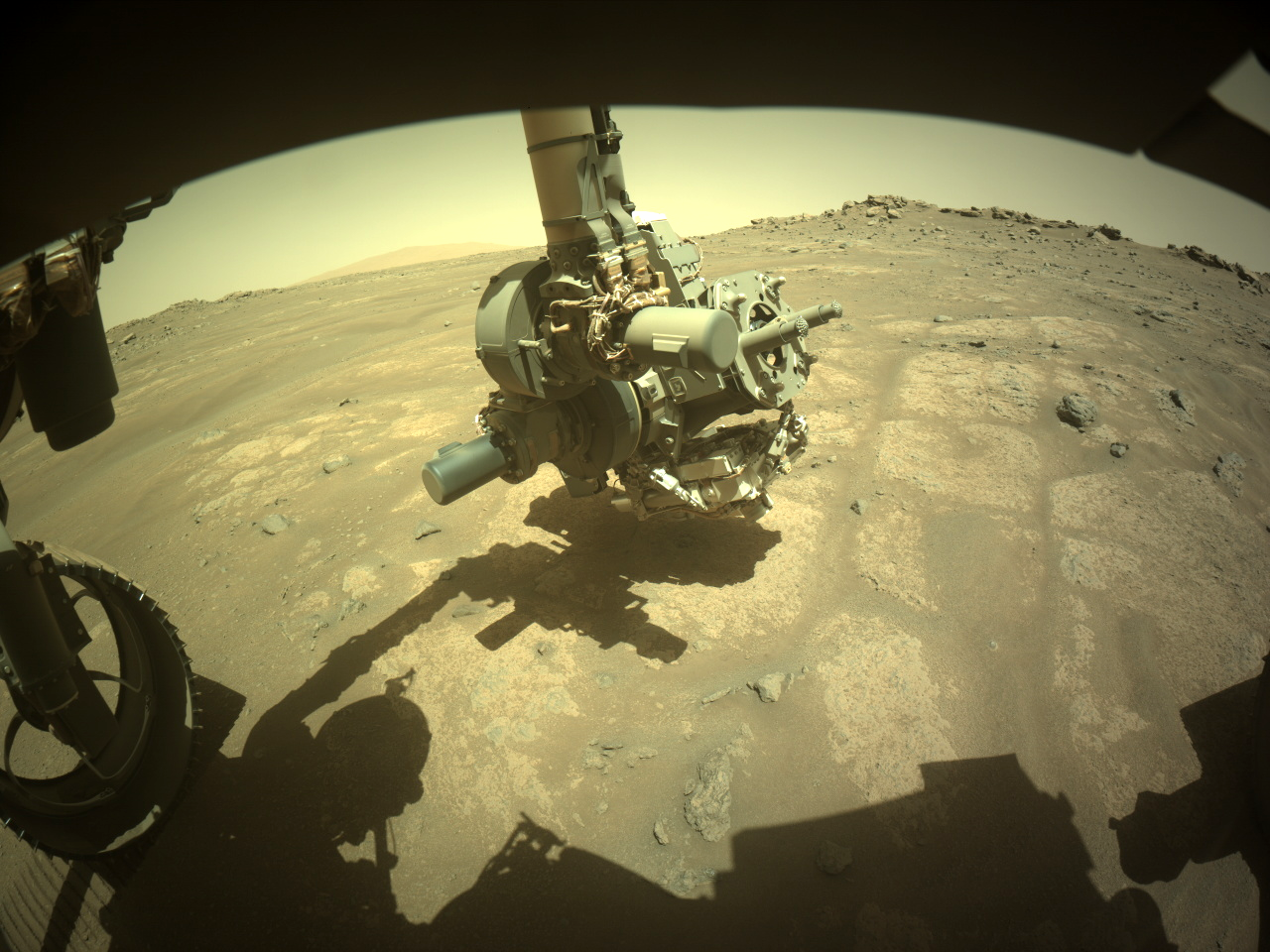
BTW - new abrasion patch! I've already posted about it!
Some quick analysis:
Well, let's see... this one isn't fractured like half the patches we've made on this outer rim of Jezero (e.g. #39, #36), has a neat circular outline, and seems to have reached a decent depth. Seems like a clean abrasion to me. So that means it would be difficult to sample, right? 😆
The target rock seems to have been chosen in part because it forms small resistant "nubs" (that is, it forms little ridges; the stuff hasn't been eroded down to near-perfect smoothness, like some other outcrops that gave the sampling system a lot of trouble). The chisel marks on this patch - the lines radiating from the center - aren't very distinct like past ones (e.g. #30, which features some harder volcanic minerals), so it is probably average in terms of hardness.
Just look at all those dark spots, dramatically sprinkled through the dark tan body of this rock! Patch #39 had dark grains too, but they were much smaller, much more rounded; the science team thinks those are spherules embedded in the rock up there. Not so down here. If you zoom in, you can see that the dark material seems to be made of clumps of different, smaller grains, rather than just being one kind of mineral. It looks like we've got a grab bag of different things going on here, which is always exciting! In fact, this one doesn't really resemble any of the prior 39 patches. And that only makes this one more interesting, because...
Percy is near the bottom of the outer rim, just above the local floor of the Nili Plateau, which features some of the oldest known rocks on Mars - and could be dramatically different from what Percy or any other rover has explored so far. Yes, we know Mars was wet, we know there was a much different climate billions of years ago - but when did that begin? We just might be in the right place to begin finding out...

These are all concise and readable, thanks!
That 18º max. roll in either direction surprised me, I thought it would be considerably less. I'm sure Percy can handle a lot more, but perhaps the sampling system can't? As for pitch, this press release from last year says that the rovers can handle up to 30º slopes, so Percy hasn't maxed out at any point on this mission yet. Considering that we should be returning to the floor of Jezero at some point, maybe we'll see those steeper slopes...
Thanks for these as always, Paul. A while back you asked for suggestions about these updates, I believe. I have a request, if it's not too much trouble: would it be possible to include a line indicating the maximum pitch angles (positive and negative) that have appeared in these updates? I find that it really helps visualization (well, mine, at least) to know the steepest slopes we've seen on the mission.
I don't blame you for being surprised. I've been trying (unsuccessfully) to find an official source for the planned future route of the rover down to the level of Nili Planum/Lac de Charmes. All I can see online is the original animation from the AGU presentation last year. Route information doesn't turn up in this year's LPSC abstracts, unless I've missed something.
In any case, my understanding always was that they were going to drive down to the edge of the ripple/TAR field at the base of the rim, so they seem to following the plan for now.
It appears they finally have moved on "today" (1502) - quite a drive. I was beginning to wonder if they were going to insist on sealing the tube before leaving the Hare Bay site/ridge, but here we are.
Those four selfies that Paul links to above all represent significant mission milestones - the deployment of Ingenuity, our first sampling attempt, our finding of a "potential biosignature" down in the valley, and the rover at the sample depot.
Perhaps this latest one can be labeled "Perseverance's Pre-Budget Cut Selfie".
I have nothing to add to your excellent, well-sourced and comprehensive reply, save this:
If the budget cuts do end up harming US (and int'l) research funding as much as some people clearly want them to, NASA and the science community has every right to use the "downward facing" shot to represent Percy being sad. And even sad Percy is more popular than the people behind these cuts.
Sky colors are generally weather-dependent, even seasonal in nature. During dust storms (see, for example, the disastrous global storm of 2018) the sky gets darker and muddier. Cloudy days and evenings can add some different colors, and then of course there are the famous pale blue sunsets.
The question of whether Mars gets blue skies has been debated for decades. Personally, aside from the sunsets, I don't see what conditions could produce the blue skies you find on other worlds with much thicker atmospheres; the dust just never completely settles out enough to wash those reddish tones away altogether. The debate will continue, but there's probably only one to settle it - sending humans.
I should add that there are plenty of shots with the horizon included from every landed mission, in case you're curious.
Paul, do you by chance know why they took those WATSON images of the mast facing downward before they started shooting the selfie?
For those unaware, Perseverance and Curiosity are both armed, like the good patriotic American rovers they are - equipped with lasers which have a definite scientific function, but which also (let's be honest) serve to dissuade any Martian critters they come across from getting too close...
Let's hope Sheriff Percy doesn't need to use it.
Original image with caption (MastCam, sol 1495)

Some quick analysis:
Not the cleanest, neatest abrasion, as we see from the broken outline from 10 to 12 o'clock, but at least this stuff didn't fracture badly, like the one further downhill that we made just last week (#38), or two other ones we made on this side of the crater rim (#36 and #33). Surprisingly, we successfully sampled the latter two, so #39 may be a candidate for drilling as well.
The target rock seems reasonably hard (note that the chisel marks - those lines radiating outward from the centre - are well-preserved and easily visible), which is not always the case: see #32, which crumbled into dust every time we tried to sample the stuff.
Those small, dark grains (toward the edge, between 1 and 2 o'clock) - pretty interesting; nothing quite like them has been found in any other target we've abraded on the rim so far. As a (very) general rule, darker minerals are often igneous (volcanic). Not saying that's the case here, but they sure stand out in this buff/tan-coloured material.
This crater rim/hillside really is an amazing place. The other patches I've linked to were taken just hundreds of metres away. We've made about 8 of these abrasion patches now over this one stretch of crater rim (roughly half a kilometre long), and we've sampled multiple times, more than in any other section. The geologic diversity packed tightly together in adjacent layers - featuring stuff like crater impact debris beside solid but heavily soaked minerals - is seriously wild!

This image is a close-up of the tailings (fine debris) left behind after Percy drilled for the latest successful sampling operation. The sharp contrast in colours seems to reveal a change found with increasing depth of drilling - the nearby abrasion patch, which is much shallower than the coring hole, mainly produced tailings of the duller, darker-toned kind seen surrounding the coring hole, as can be seen in this image comparing the two.
The row of small neat holes on the lighter-toned tailings (upper right) was created by the rover's LIBS laser (the "death-ray" originally made famous by Curiosity), which is used when we want to know what kinds of elements (e.g. iron, magnesium, calcium) the target is made of. This laser analysis was done about four sols after the core sample was originally taken, just before the rover drove off to its next field site.
What will the elemental analysis tell us? For one thing, the science team will know quickly if the change in colours is caused by a sharp difference in composition, that is, if the rock is made of fundamentally different stuff as you drill deeper down. If that is the case, it would show that this old bedrock we're driving over has more than one tale to tell about alteration, with different processes operating over just a few vertical centimetres near the surface. We already know from samples taken higher up the hill that this old crater rim has seen significant water activity... and yet earlier core samples didn't produce these multi-coloured tailings, so something different was happening at this exact spot.
If the lighter-toned tailings have the same basic elemental make-up as the duller stuff, we still learn a lot - it means something other than a change in building blocks is responsible for that notable difference in colour. It's worth noting that the ~35 prior drilling operations on this mission haven't produced more than one shade of tailings... except in the case of the super-intriguing sample #25, from the Neretva Vallis channel. I expect we'll be hearing a lot more about #25 in the next year or two - but as for the bedrock seen above in the latest one, #28, the scientists are pretty intrigued, given that they tried to get a second sample of this stuff, even before this latest laser analysis. Stay tuned!
EDITED to add context about earlier drilling operations.

My favourite trailside Martian snack. A particular delight to anyone who misses Opportunity's long traverse in Meridiani Planum, home of the world-famous blueberries.

Thanks so much for the detailed reply, Paul! I'm looking forward to playing with this data. I'll let you know as soon as I'm ready.