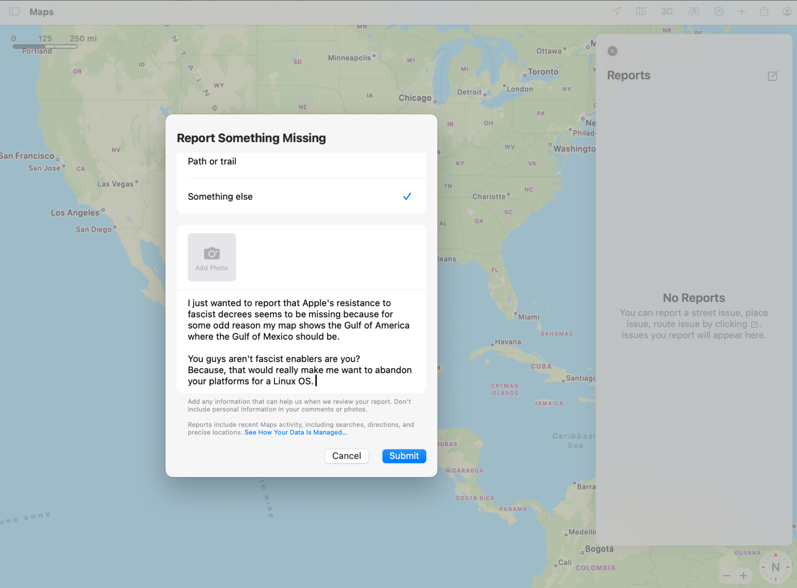
Please go to Apple Maps and harass them mecilessly
This is a most excellent place for technology news and articles.
Please go to Apple Maps and harass them mecilessly
Don't waste your time with stuff like this. Install an alternative app - OpenStreetMap is great and does have the correct name.
Truth is, these big companies don't care about you. Or your opinion. You can threaten them about "switching to Linux", but these companies will think twice and say:
how, do you think, will apple react?
I'm in Europe, here it displays «Gulf of Mexico (Gulf of America)»
I can't understand would it even have the part in parentheses in Europe. Think how silly it would look if every location had the regional name for every nearby country added in parentheses after the primary global name. It would be a mess.
Eg:
Germany (Deutschland, Allemagne, Niemcy, Germania, Saksa, )
Feels to me like special rules Apple has to stroke special fascist egos.
But maybe its not Apple and this is a name set by your local governance. You mind if I ask what country Apple maps you're looking at?
Still showing “Gulf of Mexico” on Apple Maps for me as of three seconds ago. I’m not in the US.
Google and Apple have different versions of maps depending on what your country recognizes.
For example, it will shows territories claimed by China as part of China for Chinese IP addresses, but may show them as independent territories for other countries that recognize them as such.
Yeah - I was just pointing out to the USians that it’s only changing in their country. The rest of the world will keep the original name.
There is a better chance that user reporting for this will be disabled more so than it is that this would make a difference. You know that right?
If this latest drama with Apple Maps (and Google Maps) is what pushes someone over the edge to looking for more user respecting options then the people further gone than I would really be comfortable getting used to. Both companies regularly do much more than should do more to turn you off.
why are americans so anti mexico??
Trumpers are anti-anyone who isn’t straight & white.
there are white mexicans tho..
Donde?
there are white mexicans, but i don't want to debate because i know that race was made up by humans and, well, that means you can identify as whatever race you feel closer to and it's ok
'cause racism, they think they're better somehow
Trump ≠ All Americans
It just seems that way :(
put your money where your mouth is. install linux before fruit company removes your ability to do so.
threatening companies through a feedback dialog box isnt resistance. using foss kind of scares them.
Google disabled reports and editing for it.
Did you actually write this? Holy hell that bit about Linux is cringe
lol good luck with that. Did you ever think maybe the reason he's making all these ridiculous changes, is to keep the peanuts busy, while he slashes spending? Cause it seems to be working.
Done ✅
Now let's use this opportunity to find some FOSS options like Organic Maps
If you want to go even further, you can grab StreetComplete and have fun wandering your neighborhood while contributing to OpenStreetMap by answering questions for things like business hours, road widths, road materials, etc. Unfortunately, it seems to be android only at the moment and I'm not sure if there's an iOS alternative.
I never understood StreetComplete
as i understand it, there's tons and thousands of datasets available about public infrastructure, but for some bizarre reason, StreetComplete asks us to fill in that information by hand? How stupid is that? only to make a ton of errors while manually copying in that information.
Meant to reply earlier, sorry. I assume that it waits for several inputs to verify. I have completed some streets in my area and there's no changes as of yet. I think its more of a hobby thing. I like going around, getting out of the house and getting some fresh air while having a goal. Things like Pokemon Go just didn't do it for me. I can easily see my tiny town not having much in the way of public infrastructure data, tbh.
I do understand where you're coming from. If its just not your cup of tea, it does seem silly.
As far as I know the edits are applied immediately in the backend, however the rendering of the changes can take some days.
Oh strange. I'll have to check my account. There may be some verification steps I missed, because I know you have to do something to confirm that your edits are trustworthy.
I just checked how it is for me to be sure. My Streetcomplete changes show up immediately on openstreetmap.org/edit.
I commented on apples map, too. Organic Maps for me!
I'm trying magic earth this weekend.
it's what I use, but it has such a unpleasant UI
I feel like Signal is the only FOSS App that has a good and modern UI
