Juste une petite carte idiote que j'avais faite pour un subreddit pas sérieux. En voici un autre (mais elle est moins fun) 

Juste une petite carte idiote que j'avais faite pour un subreddit pas sérieux. En voici un autre (mais elle est moins fun)
You do the same with this website (https://minecraft.ign.fr/) to a 5x5km area at most. It's a French service, it works for Wallonia too. And you should be able to export the rest of the world by changing the source to OSM, but I never tried that.

 I made this in 2022 in QGIS (but when I uploaded it on Reddit back then, you may find it as starting at Ste-Helena island.... don't ask me why, I don't remember how I made that mistake when posting it)
Westphalian borders in the sense of the Westphalian states. Aka, each of the countries ends at a defined and demarcated line instead of areas of influences. You could think of it as “modern borders”. I don't know if the term is also used in English, but last time I posted it (on Reddit) nobody questioned it, asked about that part, I learnt it at the university in my geography course.
I made this map in 2022 using paint.net

Cette carte affiche les dernières modifications apportées aux limites départementales.

Réalisée en 2022 sur QGIS, cette carte s'inscrit dans une série de cartes de la même thématique, proposant des zones tampons (ou buffer en bon anglais) de 1000 km ou "de la longueur du pays" que j'avais posté sur Reddit (plus exactement MapPorn). Cette carte a une version alternative comprenant la Terre Adélie comme entièrement française (sauf que je ne sais pas comment publier deux images à la fois sur lemmy, je découvre).


 l'image n'est pas compressée comme ça ?
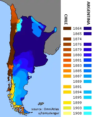
Le choix de côtes ? C'est juste la Bretagne en gros, agrandis vers le sud. Il y a eu deux îles qui ont été échangées avec les voisins seulement pour inclure un peu de variétés. Comme je l'avais dit dans l'énoncé, ce n'est pas une carte sérieuse.