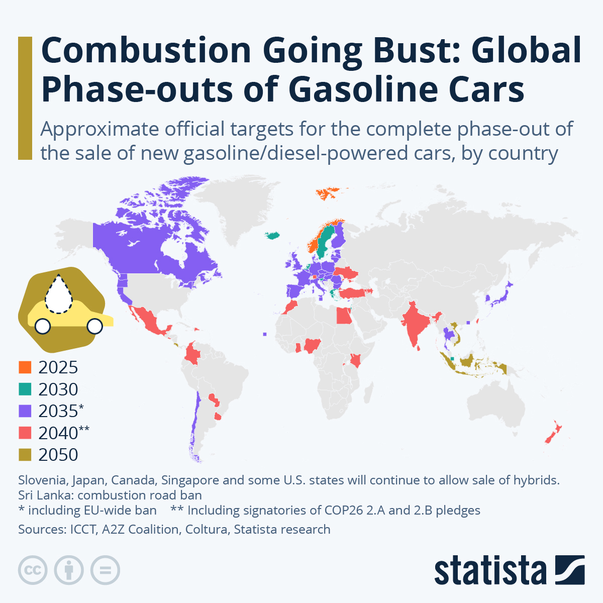
If we can just get the remaining countries to jump on board by the year 2005, we might avoid the worst effects of climate change.
Map Enthusiasts
For the map enthused!
Rules:
-
post relevant content: interesting, informative, and/or pretty maps
-
be nice
I see Uruguay there... My country has no plans to phase out gasoline cars sales by 2025. We barely have the infrastructure for the current ones really. What we have is a plan to start giving benefits and tax cuts that starts on 2025 is called "subite" translates roughly to "get on".
Edit it's 2040 but still that plan is not voted at all.
Kinda surprised China doesn't have a shade in this.. They have been mass producing cheap little evs like no one else.
Even if bans like this pass it will take several decades after those bans for ICE vehicles to actually disappear. The vast majority of cars sold here are used and buying one that's 2 decades old is not uncommon. Until battery replacements become affordable the people who are buying used aren't going to use EVs because those replacements cost more than a used ICE car.
It both saddens me and doesn't surprise me one bit that the US is so far behind that we don't even have a color.
We are fucking idiots, the lot of us. Ugh...
I mean, some of the wealthiest and most populated regions are coloured 2035, so that's that
Could you clarify how that is relevant to my comment? (Note: I'm not saying it isn't; I'm saying I don't see the connection.)
You said the US is so far behind it doesn't even have a colour.
I noted that the wealthiest and most populated regions do have a colour, indicating 2035. Perhaps I should clarify I meant those regions of the US, like California.
So at least not all of the US is so far behind, maybe that could be any consolidation?
Ah, fair enough. Thank you for explaining.
And this is true. Sadly, though, most of the US seems almost akin to a different country compared to the west coast, culturally speaking.
Good luck Northern Canadians!
They'll be fine. There's no roads either.
(Well, there's a few in the Western half, but there's enough stops you could still do it in an EV once the infrastructure is there)
Edit: Here's an example. I think charging stations are still lacking for long-distance travel, but there's no reason that couldn't change.
Glad to see the west coast and Canada banning ICE, but 2035 is late. We should be massively pushing ebikes in cities along with public transit. Get fewer car trips ASAP, even if we can't get off ICE overnight.
Canada's plan is for the exact same amount of people to be driving, but just with lithium instead of gasoline. No change to our urban planning, transit infrastructure, or car dependency. We're screwed.
Ethiopia already banned petrol cars earlier this year.
Holy shit. I wonder if this is just on paper, though, given the way countries in the region work and the questionable practicality of that before full electrification.
Poor choice of colours: distinguishing between the orange of 2025 and the red of 2040 is very hard, especially considering most people will read this on a small phone screen.
I think Norway is the only orange one
I didn't even see 2040 at first. I was shocked. I thought Mex was really on the 2025 list.
I thought about all the donkeys they would need.
I don't want to talk down your issue, but on my 5" screen they're easily differentiable. Which colours would be better? Something like a colour gradient in say green with a different projection?
I guess depending on size and colour rendition of displays it can be easier / harder, but overall I'd still say it's a poor choice.
A choice of different colours is OK, but specifically those 2 are pretty hard to distinguish. Simply changing one of them to black, which looks like no other colour used in the map, would be much better.
I don't think a gradient works for colouring a map like this: we can distinguish gradient colours when they are next to each other, but if 2 countries far away have adjacent values the colours would probably be too similar to tell the difference.
A gradient is fine and even desirable for a small number of groupings like this, and allows you to see what order places are in without reference to a key. You just need to pick one created by people who know what they are doing rather than pulling colours out your butt.
yeah i can't tell them apart at all on my phone
Ill believe it when I see it.
Mexico...next year? That's 5 months away and I haven't seen anything about major shifts to their infrastructure.
I think Mexico is 2040, but the colour legend is terrible and I'm really not sure.
According to that map Mexico is 2040, not 2025. The choice of colours is terrible.
