Earth, Environment, and Geosciences

1883 readers
61 users here now

Welcome to c/EarthScience @ Mander.xyz!


Notice Board

This is a work in progress, please don't mind the mess.


What is geoscience?

Geoscience (also called Earth Science) is the study of Earth. Geoscience includes so much more than rocks and volcanoes, it studies the processes that form and shape Earth's surface, the natural resources we use, and how water and ecosystems are interconnected. Geoscience uses tools and techniques from other science fields as well, such as chemistry, physics, biology, and math! Read more...

Quick Facts

Rules

  1. Don't throw mud. Be kind and remember the human.
  2. Keep it rooted (on topic).
  3. No spam.


Jobs

Teaching Resources

Tools

Climate


Similar Communities


Sister Communities

Science and Research

Biology and Life Sciences

Plants & Gardening

Physical Sciences

Humanities and Social Sciences

Memes

founded 2 years ago
MODERATORS
51
52
53
54
55
 
 
56
57
 
 
58
59
60
61
62
63


Vegetation cover across the Antarctic Peninsula has increased more than 10-fold over the last four decades, new research shows.

The Antarctic Peninsula, like many polar regions, is warming faster than the global average, with extreme heat events in Antarctica becoming more common.

The new study—by the universities of Exeter and Hertfordshire, and the British Antarctic Survey—used satellite data to assess how much the Antarctic Peninsula has been "greening" in response to climate change.

It found that the area of vegetation cover across the Peninsula increased from less than one square kilometer in 1986 to almost 12 square kilometers by 2021.

64
65


Birds are incredible navigators, capable of traveling thousands of miles each year to the same location. But sometimes even they end up in the wrong place at the wrong time — like inside a hurricane.

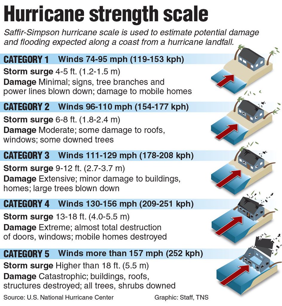
As Hurricane Helene was making landfall in Florida as a powerful Category 4 storm, radar spotted a mass in the eye of the storm that experts say is likely birds and perhaps also insects.

Seabirds likely fled the storm’s extreme winds — which reached 140 miles per hour — and ended up in the eye, where it’s calm. Once inside, they essentially got trapped, unable to pierce through the fierce gusts of the eye wall.

Storms like Helene can blow seabirds like petrels, jaegers, and frigatebirds far inland. Exhausted, they end up in unfamiliar habitats where they can’t easily find food. “It’s a challenging situation,” said Andrew Farnsworth, a bird migration expert at the Cornell Lab of Ornithology. “We know that birds do die in these things.”

66


cross-posted from: https://hexbear.net/post/3534540

As the helicopter approached Caas Tl’aat Kwah (also known as Serb Creek), a 1,600-hectare (about 3,953-acre) watershed, the forest became a blanket of deep green, cleaved only by yellow-green wetlands threaded with glacial blue streams.

“We want to conserve it for future generations,” said Charlotte Euverman, the Wet’suwet’en woman leading a fight to save this area, which includes a traditional feasting site. “We have to leave them something.”

Like most First Nations here, Wet’suwet’en never signed treaties with the Canadian or provincial governments. Nevertheless, the latter took the land and leased forested acreage to logging companies. Today just 20% of British Columbia’s old-growth forests remain.

In 2020, after decades of activist pressure, the province identified about a quarter of the remaining old growth as at high risk for logging and recommended a pause while deciding their fate. Yet today, logging has been deferred in less than half of the high-risk area

Now Caas Tl’aat Kwah is in the crosshairs of a debate over the scope of First Nations’ agency, biodiversity loss and protection – and the role industrial logging plays in amplifying Canada’s forest fires, the effects of which are being felt across the globe.

In summer 2023, more than 150,000 sq km (58,000 sq miles) burned across the country, an all-time record, carrying smoke across the continent and air pollution all the way to Europe and China.

Caas Tl’aat Kwah is not yet accessible by road, so the helicopter ride was the first opportunity for Nation member Sandra Harris to see it, despite the fact that her great-grandfather, Jack Joseph, once had a cabin there. The pilot set the helicopter down upon a boggy meadow, and DeWit, who is acting director of the Office of Wet’suwet’en, led the way through the trees to a newer cabin, where he gave a framed photo of Joseph pride of place.

Harris explained the significance of seeing the land, saying: “We have a lot of stress in our lives with racism, working with colonial systems that are so unkind to our ways.” The land is healing, she said.

“Today, we can feel our ancestors,” Harris said. “We remember our stories when we are able to put our feet on the land … There’s lots of good medicine there for us.”

Conventional wisdom has long held that increased fire severity is due not just to climate change but also dense overgrowth from fire suppression. The prescription has been to thin forests and set controlled burns. But a growing number of scientists now say that approach fails to recognize the role of industrial logging in increased fire severity: it kills complex communities of life that stabilize the water cycle.

Full Article kkkanada

67
68
69
70
71
72
73
74
75
view more: ‹ prev next ›